


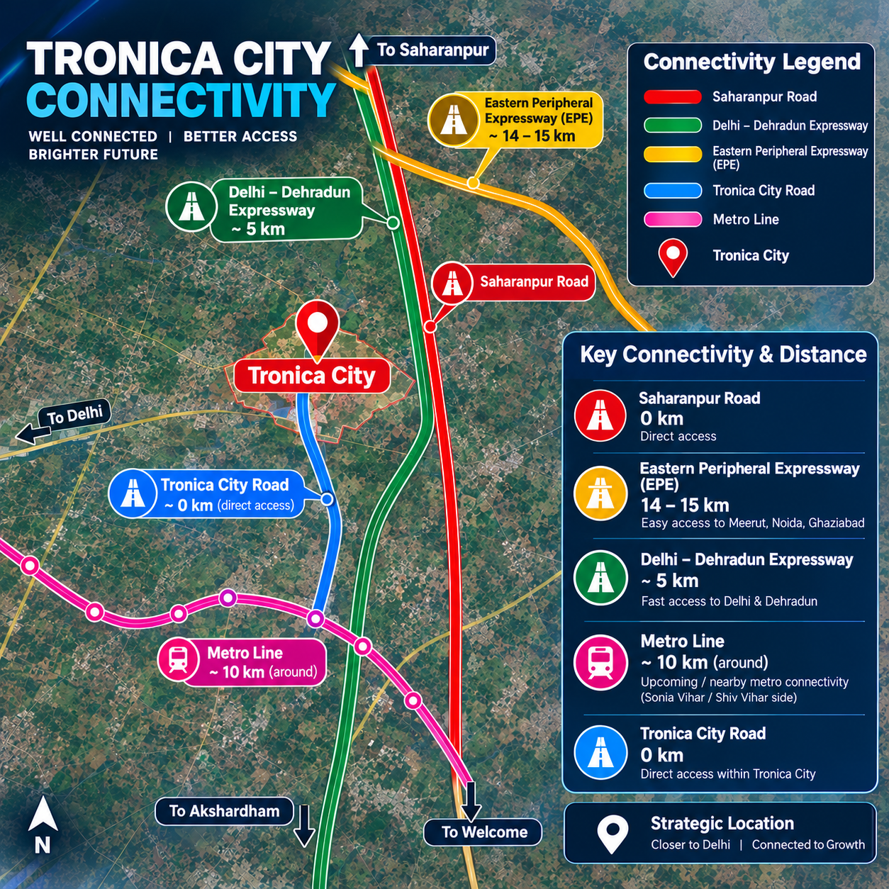
Check the Tronica City to Delhi distance, Delhi Border and Central Delhi travel time, major routes and Delhi–Dehradun Expressway connectivity.
If you are searching for the Tronica City to Delhi distance, the answer depends on which part of Delhi you want to reach.
Tronica City is located in Ghaziabad, Uttar Pradesh, close to the Delhi border. The nearest Delhi border areas are only a few kilometres away, while Central Delhi is generally around 25 to 40 km away by road.
Because Delhi is spread across a large area, the travel distance from Tronica City can vary considerably. Northeast Delhi is comparatively closer, whereas Central, South and West Delhi require a longer journey.
The road connectivity around Tronica City also connects the area with major Delhi-NCR routes, including the Delhi–Dehradun Expressway corridor and other important regional roads.
For someone looking for a simple answer, Tronica City is approximately 2.5 to 5 km from the nearest Delhi border, while Central Delhi can be around 25 to 40 km away.
The journey may take approximately 10–20 minutes to reach the nearby Delhi border and around 45–90 minutes to reach Central Delhi, depending on the exact starting point, destination and traffic.
| Delhi Destination | Approx. Road Distance | Approx. Travel Time |
|---|---|---|
| Delhi Border | 2.5–5 km | 10–20 min |
| Karawal Nagar | 5–10 km | 15–30 min |
| Yamuna Vihar | 10–15 km | 25–40 min |
| Shahdara | 15–20 km | 35–55 min |
| Kashmere Gate | 18–25 km | 40–60 min |
| Central Delhi | 25–40 km | 45–90 min |
These are approximate figures. Actual distance and travel time can change according to the specific sector in Tronica City, destination, route and traffic.
A common mistake when searching for the distance between Tronica City and Delhi is treating Delhi as a single destination.
Delhi has several major residential, commercial and administrative areas. Someone travelling to Karawal Nagar will cover a different distance from someone travelling to Connaught Place or South Delhi.
For this reason, the most useful way to understand Tronica City connectivity is to look at individual destinations rather than using one fixed distance.
The Delhi border is the closest major entry point from Tronica City.
Depending on the location within the township, the nearest Delhi border can be approximately 2.5 to 5 km away.
This makes Northeast Delhi significantly more accessible from Tronica City compared with many other parts of Delhi.
For people who regularly travel towards the Delhi side, this proximity can be an important factor when evaluating the location.
Northeast Delhi is among the most accessible parts of Delhi from Tronica City.
Areas such as Karawal Nagar, Gokalpuri and Yamuna Vihar are located closer to Tronica City than Central or South Delhi.
Approximate travel distances can range from 5 to 15 km depending on the destination.
Under normal traffic conditions, these journeys may take around 15 to 40 minutes.
Traffic around major junctions can, however, increase the travel time during peak hours.
Shahdara is another important Delhi location accessible from Tronica City.
The approximate road distance can be around 15 to 20 km, with travel times generally ranging between 35 and 55 minutes depending on traffic.
Shahdara also acts as an important connection point for people travelling towards East Delhi and Central Delhi.
Kashmere Gate is one of Delhi's major transport and connectivity hubs.
The approximate road distance from Tronica City can be around 18 to 25 km.
Depending on traffic and the selected route, the journey can take approximately 40 to 60 minutes.
Kashmere Gate is particularly important for commuters who need to connect with Old Delhi, interstate bus services and other parts of the capital.
For people travelling towards Central Delhi, the distance is generally longer.
The approximate road distance from Tronica City to Central Delhi can range between 25 and 40 km, depending on the final destination.
Important destinations in this broad area include:
Connaught Place
New Delhi Railway Station
ITO
Old Delhi
India Gate area
Central government and commercial districts
Travel time can generally range between 45 and 90 minutes, although peak-hour congestion can make the journey considerably longer.
Therefore, people planning a daily commute should check the actual route and traffic conditions rather than relying only on the distance.
Road travel is currently one of the most practical ways to travel between Tronica City and Delhi.
Depending on the destination, commuters can use different roads and connecting corridors.
Important connectivity routes around the area include:
Loni Road
Delhi-Saharanpur Road
Wazirabad-side connectivity
Signature Bridge corridor
Outer Ring Road
Delhi–Dehradun Expressway corridor
Eastern Peripheral Expressway connectivity
The most suitable route depends on where you are travelling in Delhi.
The Delhi–Dehradun Expressway is an important regional infrastructure corridor for the wider Tronica City and Mandola region.
The expressway connects Delhi with western Uttar Pradesh and Uttarakhand, providing a faster regional route towards destinations such as Baghpat, Shamli, Saharanpur and Dehradun.
The Mandola area near Tronica City is particularly relevant to this connectivity corridor.
For Tronica City, access towards the Delhi–Dehradun Expressway can be useful for both local commuters and industrial transportation.
The corridor can support connectivity for:
Passenger vehicles
Industrial transportation
Logistics movement
Commercial vehicles
Regional commuters
Travel towards western Uttar Pradesh and Uttarakhand
However, the exact distance to an expressway entry point depends on the sector of Tronica City and the access road being used.
Tronica City's location is not only about its distance from Delhi. Its position within the Delhi-NCR road network is also important.
From Tronica City, connectivity extends towards Delhi, Ghaziabad, Loni, Baghpat and other NCR destinations.
The wider road network provides access towards:
Northeast Delhi is the closest part of the capital, while Central and South Delhi are farther away.
Tronica City is located within Ghaziabad district and has road connectivity with other parts of the district.
Loni is an important nearby urban area and provides additional connectivity towards Delhi and Ghaziabad.
The Delhi–Dehradun Expressway corridor improves regional access towards Baghpat and other western Uttar Pradesh destinations.
Connectivity through major roads and expressway networks provides access to different parts of the National Capital Region.
For people who need regular access to Northeast Delhi, Tronica City's location can be convenient because of its proximity to the Delhi border.
However, the situation is different for someone who needs to travel every day to South Delhi or other distant parts of the capital.
Before choosing a residential location, commuters should consider:
Actual office location
Peak-hour travel time
Public transport availability
Road connectivity
Distance to the nearest major road
Traffic conditions
Future infrastructure development
A short distance on a map does not always mean a short commute.
Delhi connectivity is one of the factors that property buyers commonly consider when evaluating developing areas around the NCR.
Tronica City offers proximity to Delhi while being located in Ghaziabad, Uttar Pradesh.
For people evaluating residential plots or other property options, connectivity can be considered alongside:
Sector development
Road infrastructure
Electricity supply
Water availability
Nearby markets and facilities
Legal documentation
Local accessibility
Property buyers should evaluate the specific property and its surrounding infrastructure instead of making a decision based only on its distance from Delhi.
Travel time can change throughout the day.
If you are travelling from Tronica City to Delhi, it is useful to check:
Current traffic conditions
Road construction or diversions
Your exact destination
The fastest available route
Peak-hour congestion
Weather and road conditions
For daily commuters, checking the route before starting the journey can provide a more realistic estimate than relying on a fixed travel time.
The distance depends on the destination. The nearest Delhi border is approximately 2.5 to 5 km from different parts of Tronica City, while Central Delhi can be approximately 25 to 40 km away.
The nearest Delhi border is approximately 2.5 to 5 km away, depending on the sector and route.
Central Delhi is approximately 25 to 40 km from Tronica City by road, depending on the exact destination.
The journey can take around 10–20 minutes to reach the nearby Delhi border and approximately 45–90 minutes to reach Central Delhi. Traffic can significantly affect these estimates.
Yes. Tronica City is located close to the Delhi border, particularly near Northeast Delhi. Central and South Delhi are farther away.
Tronica City has connectivity towards the Delhi–Dehradun Expressway corridor through the wider Mandola and surrounding road network. The expressway provides regional connectivity towards western Uttar Pradesh and Uttarakhand.
Northeast Delhi is generally the closest part of Delhi to Tronica City. Areas such as Karawal Nagar, Gokalpuri and Yamuna Vihar are comparatively accessible.
No. Tronica City is located in Ghaziabad district of Uttar Pradesh. It is, however, part of the wider Delhi-NCR region and is located close to the Delhi border.
The Tronica City to Delhi distance cannot be represented by one fixed number because the distance changes according to the destination.
The nearest Delhi border can be only a few kilometres away, while Central Delhi can be approximately 25 to 40 km from Tronica City.
For commuters, the most important consideration is not just distance but actual travel time, route quality and traffic conditions.
Tronica City's location near Delhi, its connectivity with Northeast Delhi and access towards major regional corridors such as the Delhi–Dehradun Expressway make connectivity an important aspect of the area's location profile.
For anyone considering Tronica City for living, commuting, business or property purposes, it is advisable to check the exact sector and route rather than relying on a general distance figure.

